The Hadrian’s Wall Path
A 6-8 day stroll along the most northerly border of the Roman Empire
A 6-8 day stroll along the most northerly border of the Roman Empire
The Hadrian’s Wall Path: The Basics
WHERE IS THE PATH? The trails runs west-east across the narrowest part of England. Hadrian’s Wall no longer marks the border between England and Scotland but instead lies wholly within England, crossing the country’s two most northerly counties, Cumbria and Northumberland.
HOW LONG IS THE HADRIAN’S WALL PATH? 84 miles
HOW LONG DOES IT TAKE TO WALK THE HADRIAN’S WALL PATH? 6-8 days
WHERE DOES THE HADRIAN’S WALL PATH START? Wallsend, a suburb of Newcastle (though see ‘Tips’ below).
AND WHERE DOES IT END? Bowness-on-Solway, west of Carlisle
IS IT A NATIONAL TRAIL: Yes
HOW HARD IS THE HADRIAN’S WALL PATH? Average; there are a couple of long and remote stages but it’s a short walk, difficult to lose your way and reasonably straightforward.

Introduction

Sign at the start of the Hadrian’s Wall Path, Bowness-on-Solway.
Opened in 2003, the 13th National Trail of England and Wales has clearly had a lot of money spent on it. As this is the only trail to be accompanied along much of its length by a UNESCO World Heritage Site, this is understandable, and there was always going to be a lot of thought and care into the trail’s design and construction. Small wonder, then, that the trail took ten years to build – even though it is estimated that it took the 2nd and 6th legions of Hadrian’s army just six years to build the Wall itself!
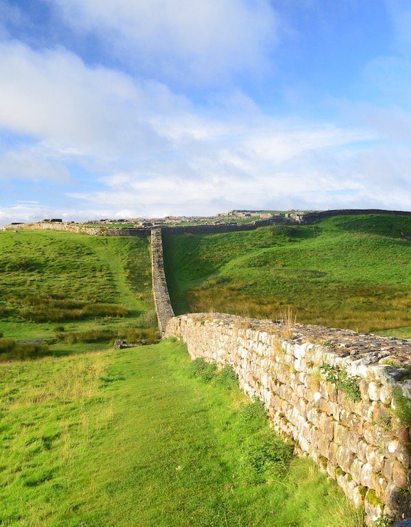
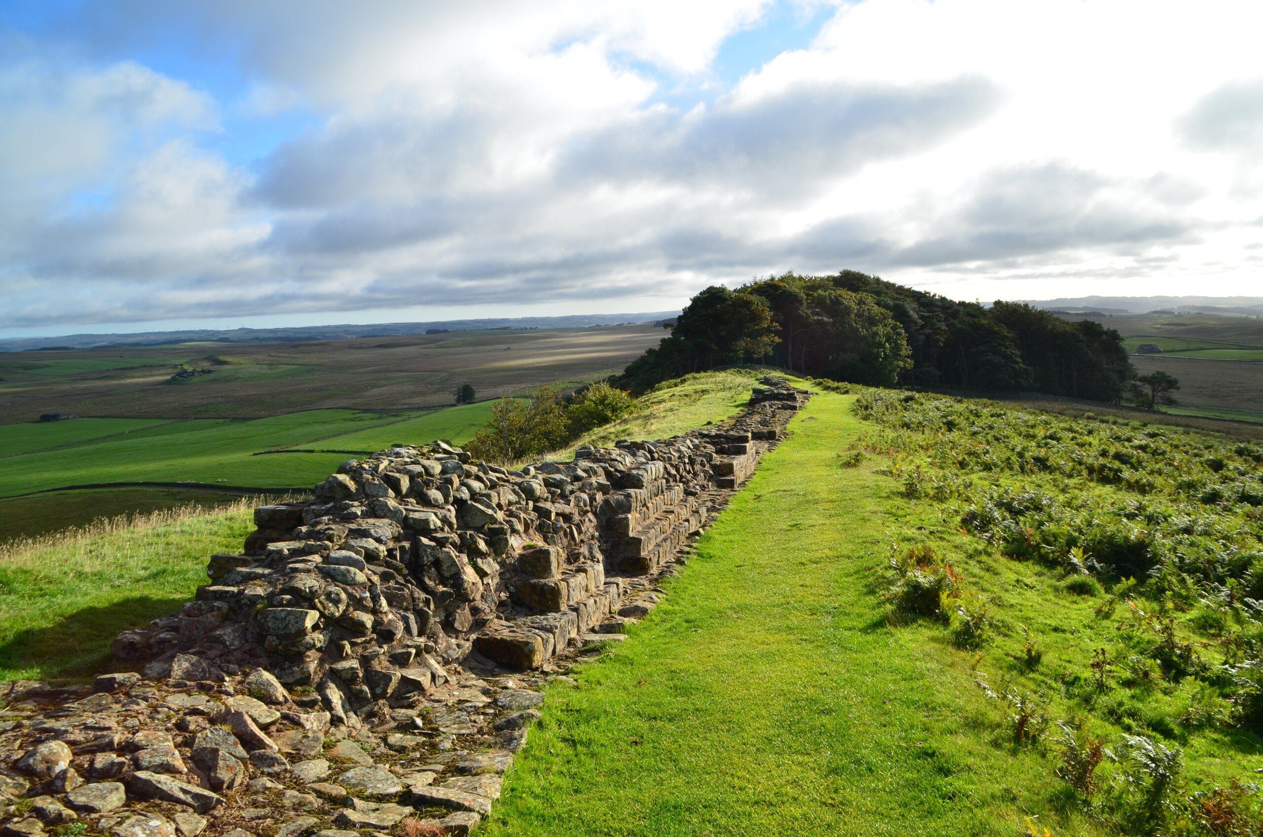
Thankfully, all that effort has been worth it. Though there’s only a few miles of the Wall left – and that which does exist seldom rises to more than half its original height – it does make a fascinating trekking companion. Punctuated by milecastles, turrets, watchtowers and other fortifications, where bits of the Wall still exist there’s plenty to interest. But even in the sections where there isn’t any Wall, the scenery is usually diverting enough to prevent boredom setting in.
Should you ‘walk the Wall’?
Roman Wall at Sewingshields, near Grindon

Local resident relaxes on the grass near the Wall.
Useful info for Wall walkers
Transport to and from the path
If you’re starting at Newcastle, you’ll have no problem getting to the start of the trail. Buses, trains, planes, ferries – Newcastle is a major transport hub and however you decide to get there, you’ll find there’s probably an option for you. Once you’re in the city then getting to the start of the trail is similarly straightforward. Newcastle is one of the few UK cities with its own underground network, with Wallsend station (note the name!) standing just 100m or so from the start of the walk at Segedunum Roman Fort. Buses from the city centre can also take you there.
At the other end of the trail, however, things are slightly more tricky. Bowness-on-Solway (the official end of the trail) is a lovely spot but it’s a little isolated, with only about five buses a day (the number 93) connecting it to Carlisle (and, note, none on Sunday!), the last one leaving at about 7pm. To save you hanging around for several hours in Bowness-on-Solway with nothing to do, find out the latest timetable from the website of Cumbria County Council. Once you’re in Carlisle, there are trains and buses to take you back home.
Transport along the Hadrian’s Wall Path
There is some sort of bus service serving just about every part of the trail, though whether it’s heading to where you want to go is another matter. The most useful bus remains the AD122 (the bus number commemorates the year in which Hadrian invaded Britain). When the trail first opened, this bus used to serve pretty much the whole path, operated frequently and was an absolute godsend for trekkers. Alas, cuts to the service mean it now runs only along the central portion of the trail, from Hexham (which is not actually on the path) to Walltown (about a day’s walk east of Carlisle). Supplemented by other local services, the trail is adequately – just! – served by local transport.
Walking Hadrian’s Wall with a dog
You can walk along the Wall with a dog, and I have done so, though in the guidebook I conclude that the trail is not actually that dog-friendly. I still hold with that conclusion today. For one thing, there are a lot of sheep and cows about so you’ll have to keep your pooch on a lead for much of the trail. Secondly, the number of B&Bs, pubs, bunkhouses and campsites that accept dogs is surprisingly small.
Another problem is the lack of bins in which to deposit any faecal matter that you, as a responsible dog owner, has picked up from the trail. As such, expect to end each day with your rucksack festooned with filled poo bags.
Nevertheless, like I say you can walk the Hadrian’s Wall Path with your dog and there are rewards for those determined enough to do so.

Road sign near Drumburgh, right on the Hadrian’s Wall Path (though nowhere near any actual Wall!)
So where might I get lost? It’s not easy to get lost on the Hadrian’s Wall Path. The money spent on the trail means the signage is very good. Besides which, for large sections of the trail you’re walking alongside a road or, if you’re not, then you may find yourself walking alongside the Wall, of course. There are a few sections where you may miss a turning – the sharp left at Drumburgh, springs to mind – and it pays to follow the book closely through Newcastle and Carlisle just to make sure you’re still on the path. But as long as you follow the signposts and the book carefully, you shouldn’t stray too far off the way….
Camping and accommodation along the Hadrian’s Wall Path
Camping along the Hadrian’s Wall Path is not straightforward. For one thing, the trail authorities are adamant that you can’t wild camp along the path. There is still a lot of the Wall that remains unexcavated beneath the trail so the rangers are keen that you don’t start driving tent pegs into the soil. Secondly, the cities of Newcastle and Carlisle have no campsites. Once out of the cities, however, you can camp along the path pretty much every night, though the weather may persuade you to secure more solid accommodation for at least one night.
Since I wrote the first edition of this guide the number of YHA hostels on the trail has fluctuated wildly. For that first edition, there were hostels strung out along the length of the trail so you didn’t need to stay anywhere else throughout your trek. For the last edition, however, there was only one, at Once Brewed (see p000), and even that was closed for reconstruction. Thankfully, the situation has improved over the last couple of years: Once Brewed has reopened, there’s now a new youth hostel in Newcastle, and these YHA establishments are supplemented by independent hostels at Carlisle, Greenhead, and two more in Newcastle. Combine these with the odd night in a bunkhouse/camping barn and you can avoid staying in a tent or B&B for every night of your trek.
As for B&Bs and hotels, there are plenty of these and some of them are charming. As mentioned before, some of them are built with Roman materials and more than one has a Roman inscription still visible on one of the stones.
Facilities along the Hadrian’s Wall Path
Food and drink With Carlisle and Newcastle bookending the path, you’ll have no difficulty places to eat and drink at either end of the trail. However, there is a shortage of eateries between the two cities – a section that takes about four days to cover in total. To be honest, even here are enough pubs, cafes and tearooms to keep you nourished. But there is one day – the rather dull stage after Newcastle, in which you spend much of the day walking alongside the B6318 – where places to eat are in short supply. But prepare carefully, plan where you’re going to eat each day and you should be fine.
Shops, banks and ATMs Once again, there is no shortage of shops, banks, ATMs and other facilities at either end of the trail -it’s the bit in middle that you have to worry about. Once you leave Heddon-on-the-Wall (just outside Newcastle), the nearest ATM isn’t until Carlisle, about four days away. If you run short of funds during this section, you’ll have to drop down to Hexham, Corbridge, Brampton or Haltwhistle to replenish your wallet. There’s nothing wrong with this (all of them are interesting and Corbridge has an excellent Roman fort) but you are adding 4-5 miles onto your trek round-trip. Shops are a little easier to come by on the trail, but only if you are after basic supplies, and even then they’re not at all frequent. For this reason, several enterprising locals have set up unmanned refreshment stalls with drinks and snacks for sale. The idea is that you pay your money in the accompanying honesty box. Even if you don’t buy anything from one of these stalls they are still great places to shelter from the rain, and you’ll often meet a fellow trekker or two cowering inside too.
Trekking companies and baggage carriers As one of the most popular trails, there’s no shortage of companies looking to convey trekkers and their baggage along the Hadrian’s Wall Path. There are several guiding companies too, and I think that, if there’s any path that is enhanced by the services of a knowledgeable guide, it’s this one. An enthusiastic and intelligent guide can really help to bring the Wall and its accompanying buildings to life.
Dangers and annoyances
There are just a couple of potential hazards. The first is one that can apply to any trail in the UK: the weather. The UK is a notoriously damp place and the north of England is a famously wet part of that notoriously damp place. Furthermore, shelter can be hard to find on the trail and if you’re walking in winter, temperatures can plummet significantly, which could lead to serious problems. There is usually a road nearby, which should be the first place you head to if you run into difficulties; but it pays to be well prepared with warm clothing and good waterproofs.
The second warning is specific to the Hadrian’s Wall Path. The very beginning of the trail, where you leave Wallsend for the centre of Newcastle, is perhaps one of the most dangerous parts of any national trail, at least if all the rumours and gossip about this stretch are to be believed. Abuse from locals, stones being thrown, even muggings – I hear stories about such incidents every time I visit the trail. I can’t confirm or dismiss any of these stories, and it might well be the case that none of them are true; I certainly don’t feel in any way threatened whenever I’m walking along this footpath. Nor, if these rumours are true, am I certain what you can do to avoid being a victim yourself, short of missing out on this section of the trail altogether, which seems a shame. But perhaps you can mitigate the outcome of any incident by, for example, leaving any valuables back in a safe place (eg your accommodation in Newcastle, or even a locker at the Newcastle city centre train station, which lies close to the trail).
I do hope I haven’t besmirched the good name of this part of the trail unnecessarily; and, like I say, I’ve never run into any trouble myself, nor met anyone who’s been a victim. But it probably pays to be aware of this section’s reputation – just in case.
Tips and hints
Many of the guide books, (including the first few editions of ours), describe the trail from east to west. This is unusual as most walks in the UK head in the opposite direction, so the weather is on your back rather than in your face.
But there’s a strong argument for walking it from west to east; indeed, I prefer it. In addition to walking with your back to the prevailing weather (which here in the UK usually blows in from the west, of course), I also think that Newcastle, with its bars and restaurants and its excellent transport links, is a better place to end the walk. That stretch through the centre of Newcastle, too, as you walk along the riverside under all the bridges across the Tyne, feels like a suitable, celebratory end to the trail (though you do have a couple of miles after this to reach the official end of the trail at Wallsend).
Doing it from west to east also means you start your walk at Bowness on Solway, and if you’re staying there for the night you’ll probably…
The Hadrian’s Wall Path: Further info
- Official National Trail webpage of the Hadrian’s Wall Path
- Wikipedia write-up of the Hadrian’s Wall Path
- Official website of Hadrian’s Wall Country, the association that looks after tourism along the Wall.
The Hadrian’s Wall Guide!
‘Recommended’ Country Walking
‘A wealth of interesting information’ Strider
‘This new edition has colour pictures …and useful profiles showing ascents and descents’ Scotland Outdoors
The guide to walking Hadrian’s Wall Path, a magnificent 84 mile National Trail that follows the course of northern Europe’s largest surviving Roman monument and a UNESCO World Heritage Site. The book includes everything you need to plan and complete the 84-mile (135km) walk through the beautiful border country between England and Scotland.
* Hadrian’s Wall Path map – plus 59 detailed walking maps (1:20,000) as well as guides to the towns and villages
* Hadrian’s Wall history
* Detailed accommodation guide with reviews – B&B’s, hotels, hostels & campsites
* Taking a dog – experienced advice on walking the path from Daisy, the author’s dog, who walked the entire trail
* Hadrian’s Wall A range of itineraries, including one-day Hadrian’s Wall walks
* Public transport information including how to get to and from the Hadrian’s Wall Path – and how to travel along it.
Buy the book:
To buy the book from Amazon, please click the link below: